
Uribarri: Difference between revisions
m r2.7.3) (Robot: Adding gl:Uribarri |
No edit summary |
||
| (2 intermediate revisions by 2 users not shown) | |||
| Line 1: | Line 1: | ||
{{Infobox settlement |
|||
[[Image:Uribarri.svg|thumb|200px|Map of the districts of Bilbao, showing Uribarri in blue.]] |
|||
| name = Uribarri |
|||
| ⚫ | |||
| settlement_type = District |
|||
| ⚫ | '''Uribarri''' is the second district of the city of [[Bilbao]], [[Basque Country (autonomous community)|Basque Country]] |
||
| image_skyline = Uribarri.svg |
|||
| image_caption = Uribarri district is highlighted in blue in this map of the districts of Bilbao. |
|||
| subdivision_type = Country |
|||
| subdivision_name = [[Spain]] |
|||
| subdivision_type1 = [[Autonomous communities of Spain|Autonomous community]] |
|||
| subdivision_name1 = [[Basque Country (autonomous community)|Basque Country]] |
|||
| subdivision_type2 = [[Provinces of Spain|Province]] |
|||
| subdivision_name2 = [[Biscay]] |
|||
| subdivision_type3 = [[Comarcas of Spain|Comarca]] |
|||
| subdivision_name3 = [[Greater Bilbao]] |
|||
| subdivision_type4 = [[Municipalities of Spain|Municipality]] |
|||
| subdivision_name4 = [[Bilbao]] |
|||
| population_total = 36181 |
|||
| population_as_of = 2016 |
|||
| area_total_km2 = 4.19 |
|||
| population_density_km2 = auto |
|||
}} |
|||
| ⚫ | '''Uribarri''' is the second district of the city of [[Bilbao]] ([[Biscay]]), in the [[Spain|Spanish]] [[Basque Country (autonomous community)|Basque Country]]. It is divided into the neighbourhoods of [[Castaños (Bilbao)|Castaños]], [[Matico-Ciudad Jardín]], Uríbarri proper and [[Zurbaran-Arabella]].<ref>[http://www.bilbao.net/castella/visitantes/planocallejero/ckal2004.pdf Bilbao City Council]</ref> |
||
| ⚫ | |||
| ⚫ | |||
==History== |
==History== |
||
| Line 18: | Line 37: | ||
*[[Mount Artxanda]] |
*[[Mount Artxanda]] |
||
*[[Artxanda Funicular]] |
*[[Artxanda Funicular]] |
||
== Sights == |
|||
{{gallery |
|||
| ⚫ | |||
}} |
|||
== References == |
== References == |
||
| Line 27: | Line 51: | ||
[[Category:Districts of Bilbao]] |
[[Category:Districts of Bilbao]] |
||
[[es:Uríbarri]] |
|||
[[eu:Uribarri (Bilboko barrutia)]] |
|||
[[gl:Uribarri]] |
|||
[[it:Uribarri]] |
|||
Latest revision as of 19:39, 12 March 2017
Uribarri | |
|---|---|
District | |
 Uribarri district is highlighted in blue in this map of the districts of Bilbao. | |
| Country | Spain |
| Autonomous community | Basque Country |
| Province | Biscay |
| Comarca | Greater Bilbao |
| Municipality | Bilbao |
| Area | |
| • Total | 4.19 km2 (1.62 sq mi) |
| Population (2016) | |
| • Total | 36,181 |
| • Density | 8,600/km2 (22,000/sq mi) |
Uribarri is the second district of the city of Bilbao (Biscay), in the Spanish Basque Country. It is divided into the neighbourhoods of Castaños, Matico-Ciudad Jardín, Uríbarri proper and Zurbaran-Arabella.[1]
It has an area of 4.19 square kilometers and a population of 36,181 inhabitants.[2]
History[edit]
For many years it was a rural area full of farms, belonging to the former parish of Begoña, as a result many street names in the district are former names of farms, like Trauko.
This district includes the quarter of La Salve, of historical importance for Bilbao as it was a traditional point for sailors returning to the city.
The area close to the Estuary of Bilbao was urbanized in the late 19th century, when the Paseo del Campo Volantin boulevard was created, lined with mansions of Bilbao's bourgeoisie. The higher lands away from the estuary were urbanized in the 1960s, with high density buildings for working classes.
Places of interest[edit]
Sights[edit]
-
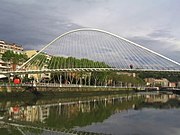 Campo Volantin boulevard and Zubizuri.

